
In the world of civil construction and industrial estate development, soil is the most volatile variable. Unlike steel or concrete, which have precise factory specifications, soil possesses unique characteristics in every square meter. For property investors and EPC (Engineering, Procurement, and Construction) contractors, this uncertainty is the primary enemy of profitability. Often, project failure is not caused by poor architectural design, but by invalid foundational data regarding the earth’s surface.
This is where the crucial role of Cut and Fill Services in Kalimantan serves as the main foundation for project success. As a region with highly challenging topography—ranging from steep hills to peat swamps—East Kalimantan demands a high level of precision in the pre-construction phase. This article will dissect in depth, from the perspective of Geodetic Engineering and Quantity Surveying, why spatial data accuracy is the key to avoiding cost overruns that can kill your project’s cash flow.
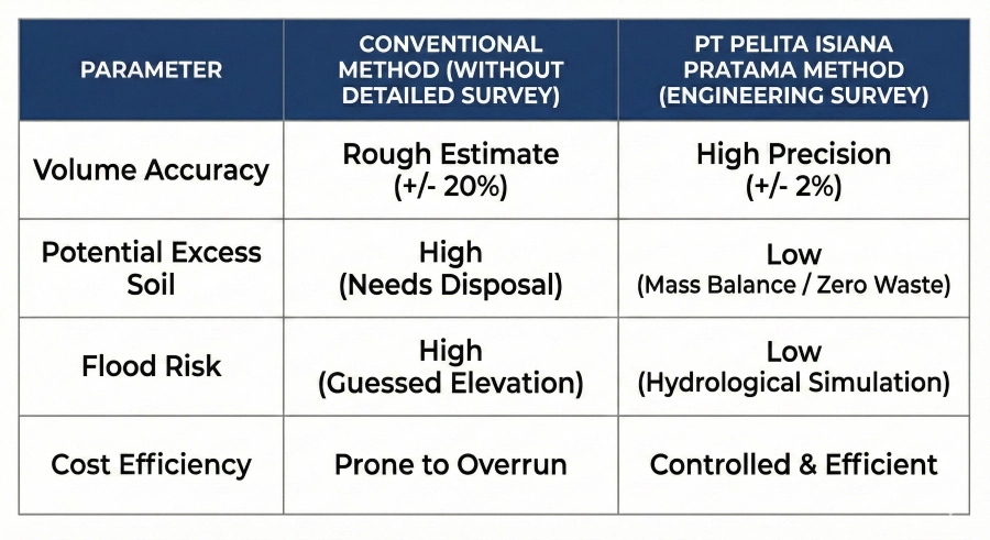
The term Cost Overrun is a nightmare for every Industrial Estate Developer. In infrastructure projects, earthwork costs can account for 20% to 30% of the total project value. However, field statistics show that earthworks are the sector most prone to budget deviations. Why does this happen? The answer almost always boils down to one thing: Topographic survey data that does not represent actual conditions.
Many developers try to save costs early on by using secondary data or rough manual measurement methods. In reality, an average elevation difference of just 10 centimeters over a 10-hectare area can result in a volume discrepancy of up to 10,000 cubic meters. If the unit price for earthwork is IDR 50,000 per m³, you have already lost a potential IDR 500,000,000 simply due to accumulated minor survey errors. Therefore, a deep understanding of geodetic techniques is not just a supplement, but a vital risk management instrument.
One fatal mistake in the planning stage is treating contour mapping merely as a licensing formality. In fact, contours are the “DNA” of the land. Without a detailed contour map (e.g., intervals of 0.5 meters or 1 meter), a Site Engineer works like a surgeon operating blindfolded.
Common mistakes include:
Taking measurement points (spot heights) with too wide a spacing (e.g., a 50×50 meter grid) on undulating terrain. This causes natural features like small trenches or mounds to go undetected, drastically changing volume calculations during execution.
In the land clearing process, the thickness of topsoil and vegetation is often not calculated separately. In practice, stripping topsoil must be disposed of or stockpiled and cannot be used as structural fill material.
Land disputes often occur due to overlapping boundaries. Imprecise cadastral measurements using standard tools (instead of Geodetic GNSS) risk triggering legal conflicts that can halt the project.
As a Quantity Surveyor, the “Holy Grail” in earthworks is achieving Zero Waste or volume equilibrium, known as Mass Balance. The principle is simple yet difficult to execute: The volume of excavated soil (Cut) should be as equal as possible to the volume of soil needed for filling (Fill) in the same area.
Why is this vital?
If Fill volume > Cut volume, you must purchase fill material from outside (quarry). This adds significant material and transportation costs.
If Cut volume > Fill volume, you must dispose of the excess soil (disposal). This requires dump truck costs, disposal site fees, and potential environmental issues.
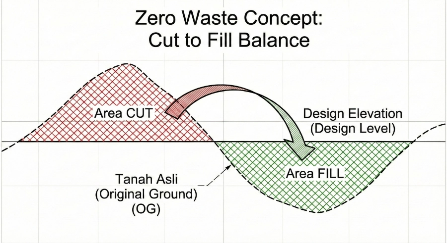
This is where accurate topographic data becomes crucial. With precise elevation data, engineers can design a Grading Plan (Final Elevation Plan) that optimizes soil movement. We can raise or lower the planned elevation (FFL – Finish Floor Level) by just a few centimeters to achieve perfect Mass Balance, saving billions of rupiah in the process.
It is also necessary to note the Shrinkage and Swelling factors. Native soil (Bank) that is excavated will expand (Loose), and when compacted, its volume will shrink. Professional Mass Balance calculations must account for these coefficients based on soil types in Kalimantan (e.g., clay or laterite).
Beyond volume, land surveying services hold a moral and technical responsibility for the long-term safety of the area, especially regarding water management. Wrong elevation is not just about soil costs, but about where the water will flow.
The law of hydraulics is deterministic: water flows from high to low. However, without accurate topographic surveys tied to a national reference (such as the Geodetic Control Network), developers will not know their land’s position relative to surrounding water bodies (rivers or city drainage).
Errors in determining planned elevation often cause:
The slope is insufficient to drain water, causing permanent ponding.
During heavy rain or high tides (for coastal areas in Kalimantan), water from the main channel actually flows back into the site because the site elevation is lower than the Flood Water Level.
Cut/fill slopes that are too steep without proper geotechnical and hydrological calculations will trigger landslides.
The era of measuring using tape measures and water hoses is over for industrial-scale projects. Millimeter accuracy is now the standard, not an option. PT Pelita Isiana Pratama adopts the latest technology to ensure that data collected from the field is a perfect digital representation of physical reality.
Integration between terrestrial and extraterrestrial methods is the key to speed and accuracy.
These tools are used to establish main control points (Benchmarks) and situation details requiring high accuracy (boundaries, road centerlines, pile positions). With satellite references corrected via Real-Time Kinematic (RTK), positional accuracy can reach fractions of a centimeter. This is in accordance with the technical measurement standards referring to SNI 19-6724-2002 regarding Horizontal Control Networks.
For large areas (e.g., 50-100 hectares), manual measurement takes weeks. With UAV (Unmanned Aerial Vehicle) technology, we can map thousands of hectares in days. LiDAR (Light Detection and Ranging) can even penetrate vegetation gaps in palm oil plantations or scrub forests to obtain Bare Earth data, which is crucial for accurate land clearing volume calculations.
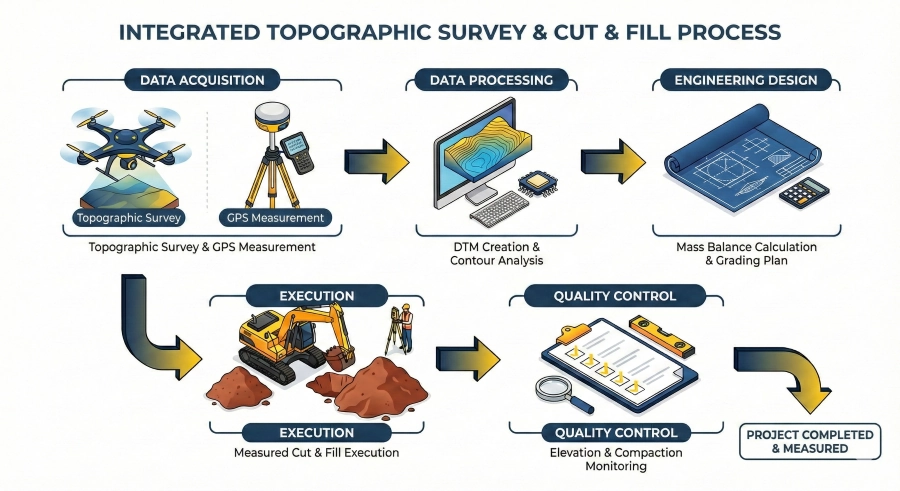
Raw data from the field cannot be used immediately. It must be processed by Geodetic experts into meaningful spatial information. This process transforms point clouds into a DTM (Digital Terrain Model).
Unlike a DSM (Digital Surface Model) which still includes trees and buildings, a DTM purely represents the earth’s skin. From this DTM, our Quantity Surveyors use software like AutoCAD Civil 3D or Surpac to perform simulations:
Viewing soil profiles at specific intervals (e.g., every 25 meters).
Using Average End Area or Prismoidal methods to calculate cut and fill volumes with high precision.
Analyzing catchment areas for effective drainage design.
Data transparency allows clients to see a 3D visualization of their land before a single piece of heavy equipment is deployed, providing visual and financial certainty.
Choosing a contractor is not just about comparing the lowest unit price. Low unit prices often hide unexpected costs due to work inefficiencies. The right partner is one capable of integrating survey data, engineering planning, and field execution under one roof.
PT Pelita Isiana Pratama’s main advantage lies in the seamless communication between the engineering team and the operational team. In many projects, surveyors only provide stakes at the beginning, and then excavator operators work based on instinct. This is a recipe for disaster.
At PT PIP, we implement a Live Monitoring system:
Our surveyors routinely check elevations during the excavation process to ensure operators do not dig too deep (over-excavation), which wastes costs, or too shallow, requiring rework.
On specific projects, we integrate digital data directly to operators, minimizing human error.
As an experienced land preparation contractor in Balikpapan and surrounding areas, we understand local soil characteristics—from soft soil in swampy areas to hard rock in hilly terrain. This synergy ensures that every liter of heavy equipment fuel is converted into effective work progress, not wasted effort.
To illustrate (based on field technical experience), let’s look at a case study of a warehouse area development on a 5-hectare hilly site in Samarinda.
A conventional contractor immediately cuts the hill and dumps the soil into the low area without calculating the swell factor. As a result, they were short of fill soil by 15,000 m³ at the end of the project because the soil shrank when compacted. The developer had to buy additional soil at an extra cost of nearly IDR 2 Billion, causing a 3-week delay.
We started with a LiDAR survey and soil analysis. We found that the local soil had a shrinkage factor of 15% when compacted. We adjusted the planned elevation (FFL) upwards by 40 cm from the architect’s initial design.
The cut and fill volume became balanced (Mass Balance). No soil needed to be bought, and no soil needed to be disposed of off-site. The project finished faster, and the developer saved billions of rupiah.
Land preparation is the foundation of your property investment. Do not let your major investment be eroded by data uncertainty. Accurate topographic measurements, smart mass balance analysis, and led field execution are the guarantees for your capital security.
PT Pelita Isiana Pratama is ready to be your strategic partner, transforming geospatial data into tangible cost efficiency. Contact our expert team today for an initial consultation regarding your land needs.
Don’t let technical risks and challenging terrain hinder your investment. Discuss your project needs with the expert team at PT Pelita Isiana Pratama. From geotechnical surveys and land preparation to jetty construction and supporting facilities for the new capital city (IKN), we are ready to provide solutions that are Precise, Efficient, and Compliant with SNI Standards.
Butuh bantuan? Tim kami siap membantu.