
In the ecosystem of massive-scale infrastructure development, the earthwork phase is the foundation that determines overall project profitability. For developers of industrial estates, palm oil plantation management, and mining operations, selecting the right partner for Kalimantan Land Development Services is a critical strategic decision. It is not merely about renting heavy equipment; it is about engineering the landscape with precise technical calculations to avoid unnecessary costs.
Kalimantan, with its unique soil characteristics—ranging from peat and soft clay to undulating topography—demands a specific engineering approach. This article delves deeply into how PT Pelita Isiana Pratama implements Mass Balance methodology and data-driven heavy equipment fleet management to save billions of rupiah in your Land Development project budgets.
Many developers fall into a classic trap: significant cost overruns mid-project because the volume of excavated soil turns out to be vastly larger than initial estimates, or target land elevations remain elusive. The root cause is almost always the same: inaccurate initial topographic data.
In a 100-hectare project, an average elevation reading error of just 10 centimeters can be fatal. Let’s calculate simply:

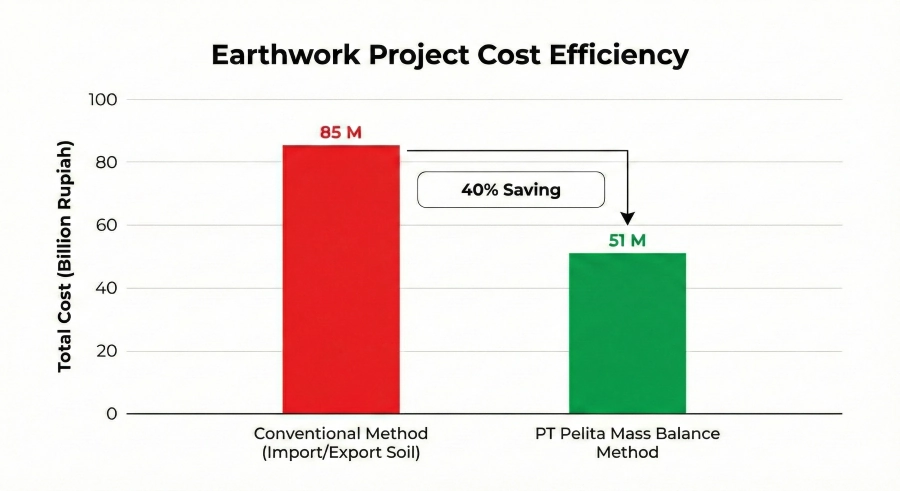
If the unit price for earthworks (cut and disposal) is assumed to be IDR 50,000 per m3, then that 10 cm error is equivalent to a loss of IDR 5 Billion. This is a substantial figure often “lost” due to conventional, less precise measurement methods.
At PT Pelita Isiana Pratama, we view contour data as the project’s “bible.” Industrial Estate Land Development cannot rely solely on manual spot heights with excessively wide grid spacing (e.g., 50×50 meters). We minimize error tolerance using the latest data acquisition technology.
To mitigate these risks, the use of Unmanned Aerial Vehicle (UAV) technology, or Drones utilizing Photogrammetry and LiDAR (Light Detection and Ranging) methods, has now become a mandatory standard.
Technical Note: Drones are capable of generating a Point Cloud with a density of millions of points per hectare, far more detailed than manual measurements using a Total Station, which only captures points every few meters.
With this data, we can generate a Digital Terrain Model (DTM) representing the true condition of the ground surface (after vegetation filtering). This accuracy allows us to detect natural water flow paths, hidden depressions, and variations in slope gradients crucial for drainage planning and slope stability. You can refer to the geospatial base map accuracy standards issued by the Badan Informasi Geospasial (BIG) to understand how vital geospatial accuracy is in construction.
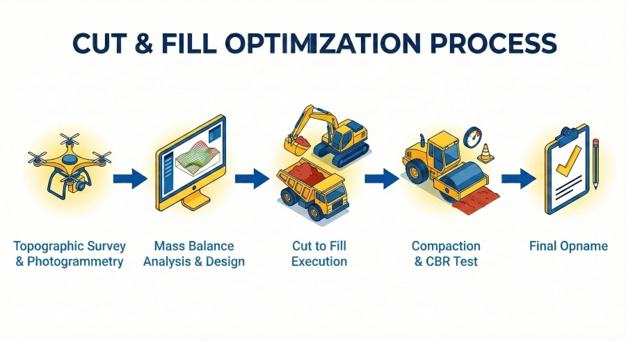
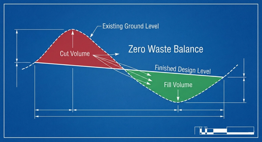
Once accurate topographic data is obtained, the next stage is grading planning. This is where the expertise of an Earthwork Engineer is tested. The primary goal is not just to flatten the land, but to achieve Mass Balance.
In Topographic Mapping & Cut Fill Services, the biggest enemy of cost efficiency is volume imbalance.
Soil Deficit: Forces the contractor to bring in soil from outside (borrow material). This increases material costs, long-distance hauling costs, the risk of damage to access roads, and potential social conflicts with local residents.
Soil Surplus: Forces the contractor to remove soil from the area (disposal). This wastes money on dumping fees and leasing disposal land.
PT Pelita Isiana Pratama’s working philosophy is Zero Waste Earthwork. We strive rigorously to ensure that soil excavated (Cut) at one point can be fully utilized to fill (Fill) another point within the same area (Cut to Fill).
How is balanced Cut and Fill achieved? Through iterative simulations on civil design software. We conduct volume analysis considering soil swelling and shrinkage factors.
Theoretically, the original soil volume (Bank Cubic Meter – BCM) will expand when excavated into Loose Cubic Meter (LCM), and will shrink back when compacted into Compacted Cubic Meter (CCM).

If initial calculations show a deficit of fill soil, our engineers will suggest adjustments to the Design Elevation. Often, lowering the planned elevation of an industrial estate by just 10-20 cm evenly across the site can eliminate the need for importing hundreds of thousands of cubic meters of soil, saving billions of rupiah without compromising the estate’s functionality.
Integrated services between mapping and physical execution are our competitive advantage. Many Industrial Estate projects fail to meet targets because survey data is handled by vendor A, while execution is carried out by vendor B. Consequently, volume disputes arise during progress opnames (surveys).
PT Pelita Isiana Pratama offers an end-to-end solution. Our internal survey team continuously monitors daily contour changes, ensuring that the billed volume is the installed volume (pay based on lines), providing total transparency to the project owner.
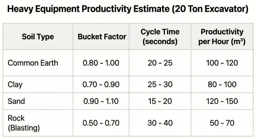
Having a great plan on paper is one thing, but executing it on a 500-hectare site in the interior of Kalimantan is a distinct logistical challenge. The key to success lies in Fleet Management.
Heavy equipment productivity does not stand alone. A PC-200 Excavator will not be productive if it has to wait for a Dump Truck (DT) to arrive. Conversely, a long queue of DTs waiting for loading is a waste of fuel.
We use Fleet Match Factor analysis to determine the optimal equipment combination:
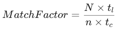
Where:
N = Number of Dump Trucks
tl = Loading time
n = Number of Excavators
tc = Dump Truck cycle time
Our target is to keep the Match Factor close to 1.0. If hauling distances increase as the project progresses, our field managers dynamically add DTs or adjust temporary disposal locations to keep productivity at its peak.
Although both involve heavy equipment, the execution techniques are vastly different:
Industrial Estates: The main focus is Soil Bearing Capacity (CBR). Fill soil must be spread in layers (maximum 30-50 cm) and compacted using a Vibro Roller or Sheep Foot Roller. Sand Cone tests are conducted periodically. Elevation tolerance is very strict because factories or warehouses will be built on top.
Plantations (Land Clearing): The main focus is Topsoil Conservation and water management. In palm oil Land Clearing, stacking methods (piling wood/biomass) must be neat and follow contours to prevent erosion. Fertile topsoil must not be buried by sub-soil. We adhere to sustainability principles aligned with ISPO (Indonesian Sustainable Palm Oil) regulations in every new land opening.
For mining clients, managing disposal areas (overburden dumping sites) is about Safety and Geotechnics. Unplanned waste soil dumps can cause fatal landslides.
We apply terracing methods with strict drainage arrangements to prevent water saturation within the fill body. Slope Stability Analysis is always conducted before determining the location and geometry of the disposal area.
Choosing a contractor for earthworks is choosing a risk partner. You need a partner who possesses both physical assets and intellectual assets.
Our experience handling various strategic projects in East Kalimantan and other Kalimantan regions has positioned us as local experts. We understand Kalimantan soil behavior—how to handle swampy areas, how to compact high-plasticity clay soil, and how to mobilize heavy equipment to remote areas with minimal access.
We do not just offer equipment rental services; we offer Value Engineering Solutions. We are bold enough to provide technical input if your initial design has the potential to waste budget, and we are ready to execute your development vision with industrial precision standards.
Efficiency in land development projects does not happen by chance. It is the result of combining accurate topographic data, intelligent Mass Balance analysis, and disciplined heavy equipment fleet management. PT Pelita Isiana Pratama exists to ensure every cubic meter of soil moved adds value to your property, plantation, or mining investment.
Do not let your project budget be eroded by inaccurate earthwork calculations.
Want to get an initial analysis and cost estimate for your land project? Contact the PT Pelita Isiana Pratama Engineering Tim today for a free technical consultation and preliminary survey.
Don’t let technical risks and challenging terrain hinder your investment. Discuss your project needs with the expert team at PT Pelita Isiana Pratama. From geotechnical surveys and land preparation to jetty construction and supporting facilities for the new capital city (IKN), we are ready to provide solutions that are Precise, Efficient, and Compliant with SNI Standards.
Butuh bantuan? Tim kami siap membantu.